As recounted by Saint Matthew, “when [Jesus] heard that John had been arrested, he withdrew to Galilee. He left Nazareth and went to live in Capernaum by the sea, in the region of Zebulun and Naphtali” (Mt 4, 12-13).
Jesus begins his public life in Capernaum, a small town on the shores of the sea of Galilee, an area of great natural beauty, located to the Northeast of the current state of Israel. In this article, I wanted to provide some brushstrokes about the natural environment and climate of the sea of Galilee, where Jesus lived during most of his three years of public life.
- The sea of Galilee

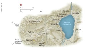
Fig,.1 Map Sea of Galilee, Footprints of Our Faith
The sea of Galilee is located in a natural depression among low mountains, in an area between the Mediterranean sea (to its West) and the Golan Heights (to the East and North, experiencing their highest elevation at Mt Hermon, 2814 meters), where the Jordan river originates. This sea, also called the Lake of Gennesaret, Tiberias or Kineret (Figure 1), is the main body of water in Israel and is formed by a sort of widening of the river, which traverses it southward. Although it is called a sea due to its dimensions, relatively large when compared to the smaller lakes in the region, it is really a freshwater body. It has a nearly elliptical shape and measures 21 kilometers from North to South, and 12 kilometers from East to West at its widest point. Its maximum depth is 42 meters. One of its key characteristics is that it is in a hollow, about 210 meters below sea level and is therefore the lowest lake on earth. As we know, temperatures are lower at higher altitudes, something that makes the lake temperatures warmer than in the surrounding mountainous areas.
- The climate near the sea of Galilee
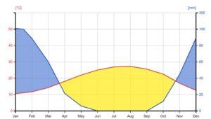
The Mediterranean climate in this zone is characterized by relatively cold and rainy winters and very dry, hot summers. It rains about 400 liters per square meter on an average year. A classic way of representing the climate of the area is presented in the graphic below (Figure 2). The blue line represents the evolution of average monthly rainfall and the red line the average monthly temperature. Two zones are evident from the graphic, one in yellow which spans from the end of March to the end of October, the warm and dry part of the year; and a complementary, cold, and rainy season which covers the rest of the year, represented in blue. The yellow area of dry and warm weather is the most frequent.

Fig. 2. Climatic diagram of the Sea of Galilee
It is next to this lake, with its geography and climate, where Jesus chose to live during his public life. He did so in a town of the Fertile Crescent, in the country of Palestine, next to the sea of Galilee, where, surrounded by hills, during the time of Jesus, agriculture thrived, livestock raising was extensive and fishing was abundant. Close to it, there were other towns and cities, particularly in the Northeast zone, where he spent time and performed many miracles, and from where his teachings resonated in all of Galilee and its bordering territories.
By Father Alfonso Sánchez de Lamadrid Rey
